Celestial Navigation Lecture – 26 April 2019 given by John Barfoot
This was the last in the Winter series of mini lectures for the 2018/19 season.
John Barfoot gave an enthusiastic lecture to an intrigued throng of sailors, with dare I say, high aspirations to learn more about this perplexing subject. We were not disappointed.
Until fairly recently, the only way for non military navigators to find their position when out of sight of land was by celestial (astro) navigation. The advent of Global Satellite Navigation Systems (GNSS) has changed all that but even today, the only backup to GNSS for amateur yachtsmen crossing oceans is celestial navigation (CN).
John, is a long standing member of the Royal Institute of Navigation. He clearly knows his subject and was keen to give us a wonderful presentation explaining the intricacies of celestial navigation in clear stages. When you compare CN with today’s GNSS its relevance in our electronic world, it appears at first sight to be irrelevant. However the sextant is definitely not yet an Object d’ Art to be kept in a glass case. We’re all very grateful to GPS but it has its limitations whilst sailing further afield when Murphy’s law kicks in, the gremlins appear and CN has to be used. He explained that given perfect conditions the very best position fix using CN would be no better than 2Nm. That’s after about 8 correction factors are applied, so we all hope it never happens.
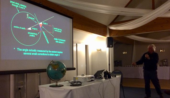
The way celestial navigation works was explained in clear steps. It started with measuring angles to lighthouses of a known height above sea level enabling you to work out your distance accurately away from it, night or day. Then once you’ve also got a bearing from the lighthouse you can plot your position. Celestial navigation works in a similar way by measuring the angle from your horizon to the sun, planet or star. Luckily these objects are so far away and the earth so large, the calculations the celestial navigator makes to find their position along the great circles becomes easier. Of course, you have to be able to see the horizon and see a known celestial object to take a reading. Not easy on a moving platform.
Your latitude is easy to find but the longitude far less so. Finding your longitude depends on many factors as the earth keeps on turning relative to the stars. You need to know the time of day the sightings are taken which is why it is so important to have accurate clocks on board ships.
In less than an hour and a half John explained how you arrive at measuring and hence calculating your position stage by stage with the help many diagrams projected on the screen. It all made sense to me at the time!
Over the years since the pioneering days CN and complex mathematics using 7 figure log tables various methods to ease the complexity has been developed as various charts, tables and almanacs calculators and computers have become available. The Greenwich observatory was the pioneer in producing all these documents that made the calculations of your position much easier and without arithmetic error. These publications have since been superseded by computer programmes and apps. Celestial navigation data uses 60 stars as well as the planets and sun. It is therefore difficult to imagine the number of tables needed to provide the necessary data for every minute of every day of the year for anywhere in the world for all those celestial objects.
I remain in awe of those early navigators and solo round the world yachtsman.
Thank you John for making a bit clearer!
– by Peter Barker